
Introduction
A methane plume with an estimated volume equivalent to roughly 1% of total U.S. natural gas system daily emissions in 2018 was released from a yet to be confirmed source in Florida, USA on May 2, 2020. The volume of the release was 170 metric tons. During measurement on May 3rd, the cumulative amount had risen to more than 300 metric tons. More than two (2) months
would pass before the results of a data mining algorithm applied to the European Space Agency’s Sentinel-5P satellite data would be brought to the attention of the public2. The mere fact that the super emitter methane release event was detected via satellite remote sensing data demonstrates how far the technology for detecting methane releases has progressed while simultaneously emphasizing the need to detect and characterize the sources of potential methane emissions before they become significant events.
A Third of California Methane Traced to a Few Super-Emitters
In California, point-source methane emissions are dominated by landfills (41 percent), followed by dairy farms (26 percent) and the oil and gas sector (26 percent). The largest methane emitters
in California are a subset of landfills, which exhibit persistent anomalous activity3. The majority of the methane super-emitters, other than landfills, are intermittent events in the energy, waste, and agriculture sectors4. It is, therefore, possible to extrapolate that the vast majority of super emitters are man-made.
Satellite-based methane detection has already delivered many successes on a global scale and will only get better with improvements in the sensitivity and resolution of the sensors. However, due to the limited number of sensors passing over the earth at any one time and the possibility of clouds blocking the target locations, satellite detection will always be subject to intermittent detection coverage. Therefore, satellite remote sensing to detect methane leaks is simply not able to provide the just-in-time methane emission awareness needed to have
prevented the super-emitter methane event that occurred in Florida. Due to the high cost and limited availability, neither can pilot-on-board aircraft equipped with methane detection
capability. Thus, we turned our attention to employing unmanned aerial vehicles (UAVs) equipped with specially built methane measurement sensors.
Detecting Methane
There are several methods for detecting methane but the most practical, cost-effective technology for measuring the amount of methane is based on the absorption of near-infrared light5 at a specific wavelength (normally 1650nm) matched to the methane molecule. “Sniffer” style methane measurement sensors measure with high sensitivity and accuracy the amount
of methane contained within a vessel of known volume. In some cases, the systems are designed for spectrographic measurement of multiple gases. As the measurement occurs internally to the sensor, the UAV with sensor attached must be flown through sufficient gas concentration density.
A more popular approach is to use a “Remote” style system illustrated in Figure 1. These “Open Path” sensors use the same single wavelength laser light emitted externally from the sensor
detecting the reflection of the laser radiation off the ground or an object back to the sensor. The amount of returned light is analyzed to determine the concentration of methane in units of ppm-meter (PPM×M) within the atmospheric volume the laser passes through.
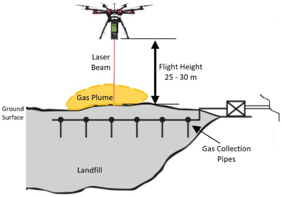
Figure 1: Drone methane detection over a landfill
The “Open Path” style methane detection systems exhibit good sensitivity and can be operated at a pragmatic distance away from the gas source. The detection swath or width of the sensing area is narrow so the sensor must be flown at a close enough ground track spacing so that the laser beam intersects the methane plume to achieve a sufficient gas concentration density. Normally this is just a small distance downwind. The lighter weight systems at about a ½ lb/0.3kg have a detection range of up to 30m while higher power systems can weigh as much as 25 lb/11kg and have a range of up to 150m. The heavier versions require a UAV similar to the one made by Swissdrones shown in Figure 2. Examples of lighter weight systems are shown in Figure 3.
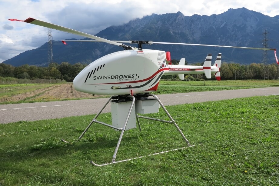
Figure 2: Heavy lift drone with IR laser methane detection system
A third type of detector is the “Scanning Remote” laser-based gas detection system where the laser is scanned from side to side creating a wide swath. The sensors exhibit good sensitivity and can also be operated from a pragmatic distance away from the gas cloud. These systems measure gas along the entire laser beam path. They weigh from 10 lb/4.5kg to 40 lb/18kg, with a detection range of up to 50 m and 150 m, respectively.
“Wide-swath hyperspectral sensor” gas detection systems use sunlight as the energy sources instead of lasers, have good sensitivity, and can be a long-distance away from the gas cloud to register a detection. These systems measure for gas along the entire sunlight reflection path from the ground or object and have units of PPM×M. Their weight is 10lb/4.5kg with a detection range of up to 100m. These systems often include a LiDAR unit to improve the sensor detection reliability.
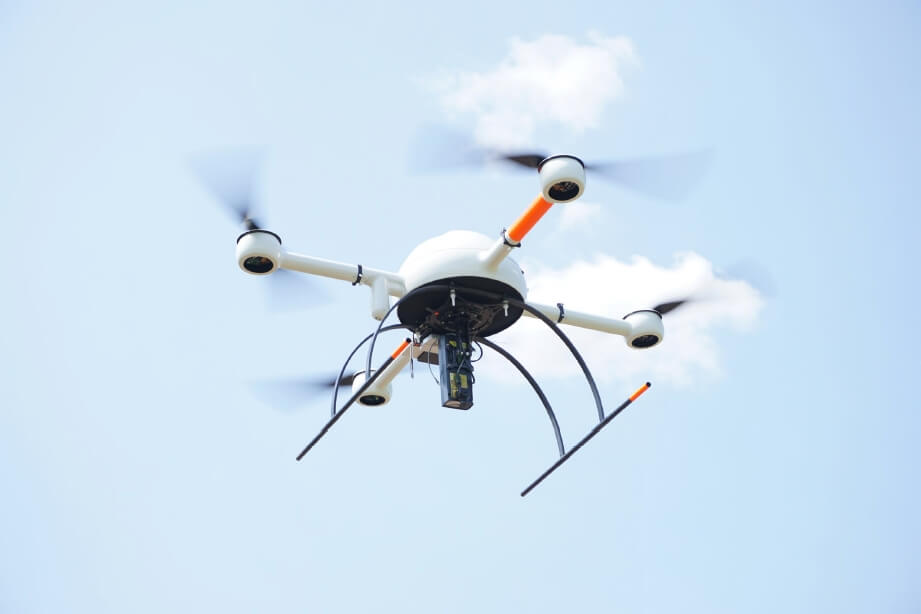
Figure 3: Light lift drones with IR laser methane detecion system. LMC mini detector (for hand-held use) installed on a small MD4-1000 drone
“Optical Gas Imaging (OGI)” is an infrared camera specially designed to detect and visualize when either the unique parts of the infrared light spectrum are absorbed or emitted by the gas. These type of sensors have good sensitivity and can be up to 100 ft/30m away from the gas cloud to register a detection. The best results are obtained when is stationary with a background that is constant and uniform. They are sensitive to multiple gases. Quantitative Optical Gas Imaging (qOGI) are OGI cameras with special software that can calculate flow rates.
Macro-level quantitative methane emission detection studies, despite their varying levels of accuracy, have already identified themes such as landfills, vents and flares, etc. with mitigation efforts being implemented. The next step is how to costeffectively ensure these solutions are continually effective.
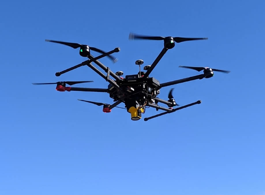
Figure 3: Light lift drones with IR laser methane detecion system. LMC Falcon detector installed on a DJI M600 Pro drone
Success to Date
The level of interest and acceptance of UAV-based methane detection platforms has grown considerably over the last 5 years and they are now the preferred method for initial detection and localization of natural gas infrastructure facilities inaccessible by other methods (ground staff, vehicle-based).
The availability of UAV methane detection payloads that can also be used for handheld surveys provided greater flexibility and value. The same resource can now inspect all the natural gas infrastructure during a single site visit.
The use of open-path remote laser methane detection payloads is advantageous over local methane detection payloads (e.g. “sniffers”) as they can measure the methane at ground level from a safe and operationally comfortable distance. This results in a higher detection reliability for smaller amounts of methane. The best results are obtained from constant above ground altitude and avoidance of directly overhead sun reflection. The maneuverability of the UAV platforms combined with payloads that produce real-time measurement data gives the operator the ability to quickly stop and reverse to verify detections raising the detection reliability to nearly 100%. As biological sources can also produce detectable methane emissions, a camera aligned with the laser is the additional asset needed to determine whether the natural gas infrastructure is the source.
The economics that are the driving force for companies to lower methane emissions should be obvious. Does the cost of detection and action to mitigate the emissions outweigh the loss of product (in the case of gas companies) and risks such as potential safety issues, violation of regulations, public opinion of their brand, etc? Reducing the cost of the first part of this equation to get companies to act has proven to be far easier than any other endeavors. High quantitative accuracy has not been needed to provide actionable information to reduce emissions.
Examples of Methane Mapping over Landfills
For landfill operators, the simple act of removing the cover dirt to enable storage of more refuse can trigger a super-emitter. During testing, a UAV sensor payload was flown over an artificial leak, a section of gas transmission pipeline which had no leaks, and then over a landfill (Figure 4) for comparison and additional verification about the system’s sensitivity.
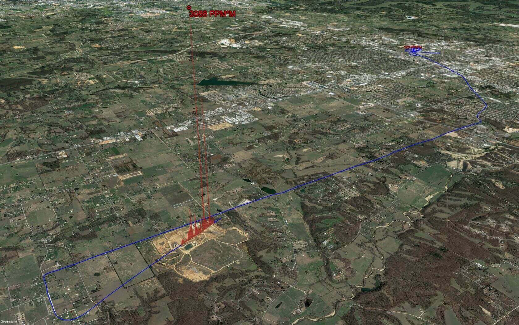
Figure 4: Landfill Methane Emissions — Single Pass Profile. The 120 PPM×M detection in the upper right corner of the landfill was 150 cubic feet per hour
The results including a maximum spike of 3088 PPM×M with a large area that was dangerous for personnel was surprising to all. The landfill operator was informed and they emonstrated they had done due diligence for safety including staff who had personal gas detectors. Interestingly, the first third of the landfill had methane capture installed and no methane emissions were detected. An example of a multi-line methane survey is shown in Figure 5.
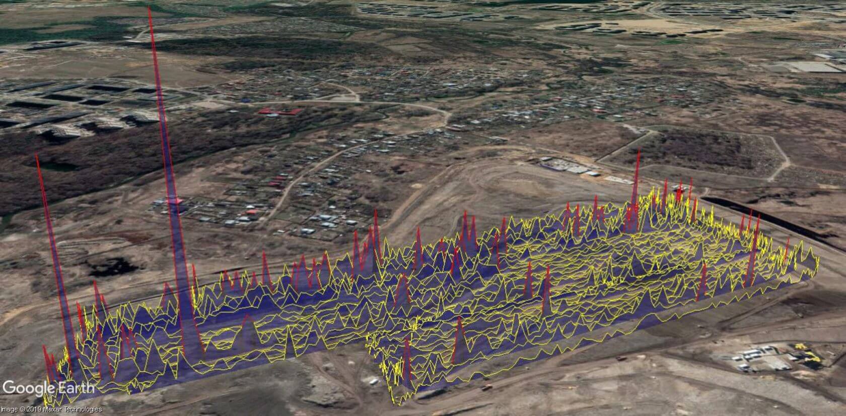
Figure 5: Results of a «Simple» Landfill Survey
Ground-based methane emission monitoring has proven ineffective due to the exposure to landfill operation, toxic chemical, and unstable terrain hazards. Economical UAV-based tools to monitor methane emissions that fit within the landfill’s already tight business models are already available and the industry continues to innovate.
Implementing aviation airspace restrictions up to 200 feet AGL above all landfills where not in conflict with existing controlled airspaces could enable automated 24/7 UAV-based Beyond-Visual-Line-Of-Sight (BVLOS) methane emission surveys giving operators a new level of safety notification and emission awareness.
Landfill operators can easily determine where to store more refuse and where to install methane capturing equipment using just the results of a simple survey (for example Figure 5), with a cost-efficient laser remote methane detection sensor UAV payload. Pergam Technical Services’ LMC payload mounted on a DJI Matrice 600 can survey 40 acres/0.4km x 0.4km in 25 minutes where each laser scan pass swath width is 1ft/0.3m from an altitude 100ft/30m.
Would better quantification, higher resolution, or an elegant heat map provide more actionable information justifying the higher price? The focus must be on value for every dollar spent. Despite rapidly increasing interest in landfill surveys, only a few hundred of these sensor payloads are currently sold worldwide per year. Increased demand would reduce their cost further by as much as a third via the economics of higher volume manufacturing.
Methane Leak Detection for O&G Facilities and Infrastructure
UAV-based methane detection also provides value at the micro level such as gas companies’ facilities and distribution pipeline networks. The limitations inherent to every business model dictate that not every leak in a natural gas facility or infrastructure can be fixed. UAV-based remote quantitative emission measurements can be directly used to prioritize emission mitigation resources, but at a price and does not alone characterize the future potential emissions of the source. A primary focus area of the methane sensor industry is to find cost-efficient methods to quickly detect, localize, and quantify leaks and the leading candidates are UAV-based payloads.
An example of the potential benefits of UAV-mounted methane detection is in regard to a recent incident in Florida1, mentioned in the Introduction, where a gas company maintenance operation was suspected of a gas leak. he same UAV methane detection system which surveyed the landfill could have been patrolling downwind of the Florida-based gas company’s maintenance event to provide real-time monitoring and document that their actions were not the cause of the Florida plume.
New Gas Detection Technologies and their Cost-Effectiveness
The exciting new technologies are quantitative Optical Gas Imaging (qOGI), scanning laser remote methane detection sensors, and wide-swath hyperspectral gas detection sensors. qOGI can achieve quantitative accuracy between 30% and 50% with a professionally customized calibration configuration for the conditions, a particular environment, and hovering long enough to take several measurements. Additionally, qOGI has the benefit of detecting multiple gas types.
The total cost of detection which includes training and setup time is in the order of 7 times higher as compared to the costefficient laser remote methane detection sensor UAV payload previously described.
Scanning laser remote methane detection sensors have approximately 10ft/3m wide laser pass swath width and have achieved similar accuracy results from 100ft/30m while in motion and with fewer limitations, but with a total cost of detection estimated at over 13 times higher as compared to the costefficient laser remote methane detection sensor UAV payload. This technology is the most advanced for large area quantitative methane mapping, but the high cost is significantly limiting its use.
Wide-swath hyperspectral sensor gas detection payloads have slightly lower sensitivity and quantitative ability than scanning laser remote methane detection sensors with a total cost of detection estimated at only 10 times higher as compared to the cost-efficient laser remote methane detection sensor UAV payload. This technology is already used to monitor agriculture and has a strong potential of becoming a cost-efficient method for large area quantitative methane mapping as the gassensitive versions mature. All three methods require line-ofsight with the leak source for greater quantitative accuracy. Numerous efforts are underway to improve the performance and cost of these technologies.
UAV-based gas “sniffer” detection sensors can have quantitative accuracy of 15%, but must take many measurements only 2-3 yards/meters from the leak source which can be in the hazard zone and time-consuming. Payload pairing a laser remote methane detection sensor with either a sniffer or OGI sensor takes advantage of the strengths of both to provide results faster, but at a higher cost.
The optimal solution for UAV-based natural gas distribution pipeline leak inspection, for example in suburban neighborhoods, has not yet been achieved. It will take a revolutionary change in UAV capability, noise reduction, and economics in order to effect change.
Once large scale autonomous Beyond-Visual-Line-Of-Sight UAV operations are allowed, gas companies can take advantage of UAV’s lower cost per mile, lower environmental impact, and near-instant availability to inspect their high-risk areas daily and their entire networks whenever needed or desired, finding leaks when small and simpler to resolve/repair. Due to cost, the market has stagnated to only around a third of the US transportation pipeline being inspected from aircraft with active methane detection equipment and normally only annually.
Quantitative Methane Mapping via Drone
Large area quantitative methane mapping is the next frontier for UAV-based methane detection. Mapping of methane natural sources on a global scale (e.g. tidal flats, melting permafrost, etc) over time to understand their effects is of critical scientific importance. A cost-efficient method has yet to be established and sorely needed. Even the fixed-wing aircraft quantitative efforts have been limited and mainly publicly or charity funded. The methane sensor industry is focused on the wide swath sensors, but continues to hope that the clever application of a bit of science will determine a method for repeatably accurate quantification using the lower-cost methane etection
payloads. The research to date has established the largest source of variation in the quantification calculation is in the actual methane measurement. A UAV’s freedom to fly closer to the ground and a tighter survey pattern than aircraft and the ability to fly a precise automated flight pattern with minimal changes in altitude above ground have already been shown to improve the quality of the measurement data.
Several advanced UAV operators are experimenting with complex multiple sensor payload packages such as the addition of rangefinders and light intensity sensors in combination with ground sensors providing environmental data along with advanced analysis and modeling software. The ease of mounting almost any payload combination continues to be a strength of UAV-based measurement.
Summary and Conclusions
Fifteen years of dialogues over detection reliability, inspection beam width on the ground, and equipment sensitivity have curtailed the mainly helicopter-based natural gas leak detection efforts as customers have become increasingly confused whose technology to trust with their limited funding. The reduced operational cost per mile/kilometer of UAVs, the dramatically reduced cost of the methane detection sensors, and the flexibility of both UAV operations and payloads will solve this problem and lead to significant expansion not only in the natural gas transmission pipeline leak inspection market.
The focus now is on awareness by educating individual companies to eventually transform the normal practice of industries, supporting those who desire to find new ways of using existing sensors, and the continued development of better sensors. Just-in-time methane emissions awareness will lead to low-methane emissions business models. Even with our differences, the methane detection sensor industry is united in our commitment and passion to reduce emissions, and we stand prepared to engage further. A key enabler to long term methane emissions reduction is not only extensive global emissions mapping but also timely economical monitoring as well.


